1.1 Physiographic units
The study area lies within the Sydney Basin which is a fairly simple
asymetrical structural basin which has its centre at about Fairfield and
extends from Port Stephens to Bateman's Bay. The general character of
the Basin is shown in Figure 6. Within the Basin, the principal
physiographic units relating to the study area are the Cumberland Plain
in the centre, the Hornsby Plateau to the north and north east, and the
Blue Mountains Plateau to the west. In parts of the study area there is
a sharp transition between the plain and plateaux while in others the
change is marked only by gently rolling hills with elevations ranging
from 40-80 metres. These characteristics are shown on Figure 7.
The Cumberland Plain is drained by meandering creeks flowing to the
Hawkesbury and Parramatta Rivers. The whole Plain, with the exception of
a few rounded hills, typically has an elevation of less than 30 metres
and a range of 10-60 metres. The surrounding plateaux have been formed
by warping and have been deeply incised by their antecedent streams.
The Blue Mountains Plateau rises abruptly from the Cumberland Plain
along the north-south line of the Lapstone monocline to a height of over
150 metres above sea-level near Glenbrook and, with associated faulting,
to over 570 metres near Kurrajong Heights.
Along the north western boundary of the study area, the Hornsby
Plateau, with an elevation less than 300 metres, is arbitrarily
separated from the Blue Mountains Plateau by the gorge of the Colo
River. In the south east, this plateau rises from the Cumberland Plain
along a warpline extending from the vicinity of Cattai to Botany Bay. In
general the plateaux have an elevation of about 200-220 metres with
gullies down to 80-100 metres along drainage lines. Steep slopes with
elevation changes of over 100 metres are not uncommon.
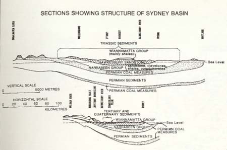
Insert from Figure 6 showing geographical
characteristic of the Sydney Basin
1.2 Geological history
The geology of the Sydney Basin and the study area is predominantly
the result of sedimentation and phases of earth movements. The
underlying structure of the Basin was laid down during the Permian and
earlier geological periods under marine and marshy conditions which,
with major earth movements, produced the sandstone and siltstone
formations and intervening coal measures lying at considerable depths
under Sydney.
The geological formations that outcrop in the study area are mainly
Triassic sediments which were deposited in lakes in the unfolded parts
of the geosyncline of the Sydney Basin that had developed by the end of
the Permian. The first group of sediments, which only occurs on the
fringes of the study area, was the Narrabeen Group which has a wide
range of sediments. This was followed by the Hawkesbury Sandstone and
lastly the Wianamatta Group containing, in the study area, Ashfield and
Bringelly Shales which were deposited in a series of isolated
depressions. Since Triassic times the surface of the Sydney basin has
been above sea level and consequently any further deposition of
sediments have been terrestrial.
During the Jurassic period the sediments of the Sydney Basin were
intruded by small bodies of magma, the best known in Sydney being the
Prospect dolerite intrusion but represented in the study area by the
volcanic breccia outcrop at Marsden Park.
The next depositions in the Basin were Tertiary freshwater sediments.
Very little surface evidence remains but a major outcrop occurs in the
study area in the sands and clay of Londonderry-Windsor area and also
the sands at Maroota. The tertiary deposits were typically a coarse
gravelly layer up to eight metres in thickness underlying silt and sand
of an average depth of about six metres. Subsequent weathering has
turned much of the sandy silt into siliceous clay. At the close of the
Tertiary period earth movements occurred which produced an uplift of 600
metres in a large area of eastern Australia. These movements produced
the Blue Mountains and Hornsby Plateaux described above, with the
lagging behind of part of the peneplain becoming the Cumberland Plain.
This movement produced the entrenching of existing rivers including the
Hawkesbury-Nepean and the Grose and the development of new rivers of
which the Colo is one.
The Quaternary period saw a rise in sea level of about 60 metres
which drowned the lower Hawkesbury River together with the great part of
the eastern Australian coast. The Quaternary deposits were formed by
flood or wind and are well in evidence in the study area in the flood
plain of the Hawkesbury River and its tributaries. These deposits
consist of varying depths of estuarine and river sands and gravels,
typically six to eight metres of gravel overlaid by about six metres of
sandy silt.
The geology of the area that now appears as a result of the above
history is shown on Figure 6. It can be summarised as Hawkesbury
Sandstone in the east and around the northern and western fringe, with
Ashfield Shales of the Wianamatta Group occurring in the Glossodia area
and in a band from Pitt Town to Kellyville. Bringelly Shales, also of
the Wianamatta Group, are found further west along a line from Vineyard
to Quakers Hill and at Marsden Park. The south western part of the study
area is dominated by the more recent deposits containing a variety of
sand, silt, gravel and clay formations.
Soil types relate to parent geological material and subsequent
weathering. The soils derived from the sandstone are generally poor but
the repeating ridge-slope-gully formations produce a number of types
ranging from barely structured sandy soils on the ridges and steep
slopes to deep, strongly structured sandy clays in the gullies. The
rolling terrain of the shale areas with slopes rarely exceeding 20 per
cent and the different parent material produces heavy textured red
podsolic soils on upper and mid slopes and yellow podsolics on lower
slopes and flat drainage depressions. On the alluvials the soil type
depends on the age of the sediment. The tertiary related soils cover a
wide range from sand deposits to gravel, silt soils and, at their most
developed, duplex soils with distinct clay subsoils. The soils on the
younger alluvials range from sandy loams to clays and often show little
structure.
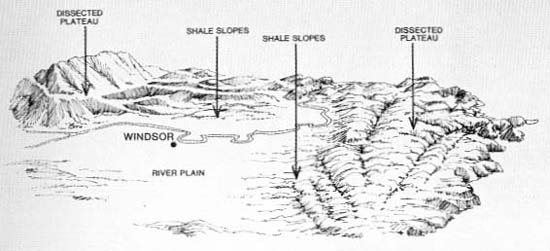
Insert from Figure 7 showing the topography of the
north-west sector of the Sydney Basin
1.3 Landscape systems
The physiographic units of the study area translate into three major
landscape systems - the River Plain, Dissected Plateaux and Shale Slopes
which are illustrated on Figure 7.
1.3.1 River Plain
The River Plain system has an area of 25,600 hectares and features
the Hawkesbury River along its western edge and the Eastern, South and
Ropes Creek tributaries flowing through its centre. Despite the
reasonable fertility of the Plain's alluvial soils, the type of
vegetation it supports is influenced primarily by the low rainfall
resulting from the effect of the surrounding uplands. The characteristic
vegetation community is a sparse eucalypt woodland with a slightly more
dense open forest developing where the water table is higher and the
water holding capacity of the soil is increased.
Soil type is the next most important factor influencing vegetation
type on the Plain. The rich agricultural soils of the Quaternary
alluvium support one type of canopy community, plus swamp communities
and riverbank trees and shrub thickets. Because of the fertility and
higher permanent water table of these soils the tree community is
usually quite dense (i.e. a forest).
The vegetation on the Tertiary alluvium relates to the degree of soil
development. Areas with clay subsoils support forests while the other,
less clayey, soils all support sparser woodlands. The tree species of
the woodlands vary in response to small changes in the proportion of
sand-to-silt-to-gravel in the soil.
Along the Hawkesbury River floodplain are a number of small areas of
perennially high water table. Natural vegetation here is predominantly
sedgeland and reed swamp with the occasional occurrence of swamp forest.
All are classified in this survey as wetlands.
1.3.2 Dissected Plateaux
The Dissected Plateaux landscape system covers an area of 74,770
hectares. The Plateaux to the east and west experience a higher rainfall
than the River Plain mainly because of their orographic effect. Due in
large part to the higher rainfall, the vegetation is more dense than on
the Plain. The soil, however, is very poor and drains freely. This
results in an open forest formation on the upper slopes and sparse
woodlands on ridgetops are not uncommon.
On the Plateaux there are also variations in the vegetation in
response to differing aspects and soil type and structure. The
sclerophytic adaptation vegetation for growth on poor soils with good
rains means that the vegetation reacts strongly to the extra drying
effects of full exposure to sunlight. Thus, a different type of
vegetation grows on north facing slopes than on south facing slopes.
It is because of this variety of environmental conditions and the
vegetation's response to them that the flora of the Hawkesbury Sandstone
is often called a complex of types.
On parts of the Plateaux the vegetation, wh11e having much in common
with the other Plateaux types, is more dense and has a more varied
understorey. This occurs where shale caps on the sandstone and active
weathering of the sandstone have produced soils that are richer and have
higher waterholding capacity.
The Dissected Plateau in the north of the study area is different
from the others in that it does not have a higher rainfall than the
River Plain. The lower rainfall reduces the complexity of the vegetation
and results in a wider occurrence of woodland formation which is less
responsive to soil type and aspect as well.
The Dissected Plateaux also have wetland communities. These are
mainly mangrove/saltmarsh areas in tidal re-entrants along the lower
Hawkesbury and Berowra Creek.
1.3.3 Shale Slopes
The Shale Slopes landscape system occurs where the Ashfield and
Bringelly Shales remain in the north and east of the study area. The two
major areas of this system total approximately 25.670 hectares. The
vegetation of the Shale Slopes reflect, the gradual change from the
Plateaux to the River Plain and rainfall similar to the latter. However,
it should not be considered a transition vegetation type since outside
the study area to the south this zone occurs without culminating in a
plateau. In fact it constitutes the major vegetation type of the
Cumberland Plain.