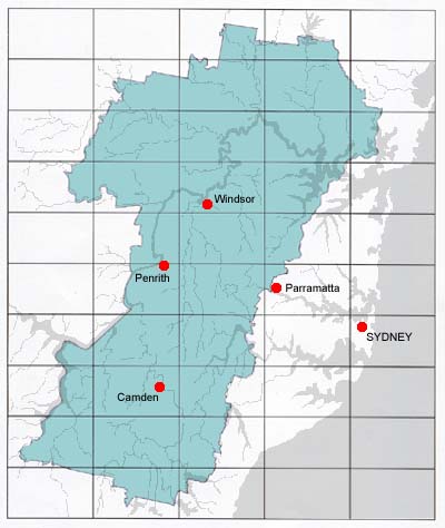
Geographical Indication Map
Based on the information provided in the Area Boundaries and Textual
Description sections of this document, the proposed Sydney Wine Region can
be viewed as the displayed map in the figure below.
Area Boundaries
The area boundary used to support the textual
description of the geographical indication for "SYDNEY" is
presented on the following official maps:
MOUNT WILSON TOPOGRAPHIC MAP
Scale 1:25,000
Sheet 8930-1N
Third Edition
Produced by New South Wales Department of Information Technology
and Management - Land Information Centre
Copyright Land Information Centre, 2000.
|
WOLLANGAMBE TOPOGRAPHIC MAP
Scale 1:25,000
Sheet 8931-2-S
First Edition
Produced by Central Mapping Authority of New South Wales
Copyright New South Wales Government, 1988.
|
MOUNTAIN LAGOON TOPOGRAPHIC MAP
Scale 1:25,000
Sheet 9031-3-S
First Edition
Produced by Land Information Centre - New South Wales
Department of Lands
Copyright New South Wales Government, 1986.
|
COLO HEIGHTS TOPOGRAPHIC MAP
Scale 1:25,000
Sheet 9338-3-N
First Edition
Produced by Central Mapping Authority of New South Wales
Copyright New South Wales Government, 1989.
|
ST ALBANS TOPOGRAPHIC MAP
Scale 1:25,000
Sheet 9031-2-N
First Edition
Produced by Land Information Centre - New South Wales
Department of Lands
Copyright Land Information Centre, 1974.
|
AUBURN TOPOGRAPHIC MAP
Scale 1:25,000
Sheet 9031-1-S
First Edition
Produced by Land Information Centre - New South Wales
Department of Lands
Copyright New South Wales Government, 1989.
|
KULNURA TOPOGRAPHIC MAP
Scale 1:25,000
Sheet 9131-4S
Third Edition
Produced by New South Wales Department of Information Technology
and Management - Land and Property Information New South Wales
Copyright Land and Property Information NSW, 2001.
|
MANGROVE TOPOGRAPHIC MAP
Scale 1:25,000
Sheet 9131-3N
Produced by New South Wales Department of Information Technology
and Management - Land and Property Information New South Wales
Copyright Land and Property Information NSW, 2001.
|
WYONG TOPOGRAPHIC MAP
Scale 1:25,000
Sheet 9131-2N
Third Edition
Produced by New South Wales Department of Information Technology
and Management - Land and Property Information New South Wales
Copyright Land and Property Information NSW, 2002.
|
GOSFORD TOPOGRAPHIC MAP
Scale 1:25,000
Sheet 9131-2S
Third Edition
Produced by New South Wales Department of Information Technology
and Management - Land and Property Information New South Wales
Copyright Land and Property Information NSW, 2001.
|
GUNDERMAN TOPOGRAPHIC MAP
Scale 1:25,000
Sheet 9131-3S
Third Edition
Produced by New South Wales Department of Information Technology
and Management - Land and Property Information New South Wales
Copyright Land and Property Information NSW, 2001.
|
COWAN TOPOGRAPHIC MAP
Scale 1:25,000
Sheet 9130-4N
Third Edition
Produced by New South Wales Department of Information Technology
and Management - Land Information Centre
Copyright Land Information Centre, 2000.
|
HORNSBY TOPOGRAPHIC MAP
Scale 1:25,000
Sheet 9130-4S
Second Edition
Produced by New South Wales Department of Information Technology
and Management - Land and Property Information New South Wales
Copyright Land and Property Information NSW, 2001.
|
PARRAMATTA RIVER TOPOGRAPHIC MAP
Scale 1:25,000
Sheet 9130-3-N
Second Edition
Produced by Central Mapping Authority of New South Wales
Copyright New South Wales Government, 1986.
|
PROSPECT TOPOGRAPHIC MAP
Scale 1:25,000
Sheet 9030-2N
Third Edition
Produced by New South Wales Department of Information Technology
and Management - Land and Property Information New South Wales
Copyright Land and Property Information NSW, 2001.
|
LIVERPOOL TOPOGRAPHIC MAP
Scale 1:25,000
Sheet 9030-2S
Second Edition
Produced by New South Wales Department of Information Technology
and Management - Land and Property Information New South Wales
Copyright Land and Property Information NSW, 2001.
|
CAMPBELLTOWN TOPOGRAPHIC MAP
Scale 1:25,000
Sheet 9029-1N
Third Edition
Produced by New South Wales Department of Information Technology
and Management - Land and Property Information New South Wales
Copyright Land and Property Information NSW, 2001.
|
APPIN TOPOGRAPHIC MAP
Scale 1:25,000
Sheet 9029-1S
Third Edition
Produced by New South Wales Department of Information Technology
and Management - Land Information Centre
Copyright Land Information Centre, 2000.
|
BULLI TOPOGRAPHIC MAP
Scale 1:25,000
Sheet 9029-2N
Third Edition
Produced by New South Wales Department of Information Technology
and Management - Land Information Centre
Copyright Land Information Centre, 2000.
|
BARGO TOPOGRAPHIC MAP
Scale 1:25,000
Sheet 9029-3N
Third Edition
Produced by New South Wales Department of Information Technology
and Management - Land Information Centre
Copyright Land Information Centre, 2000.
|
HILL TOP TOPOGRAPHIC MAP
Scale 1:25,000
Sheet 9929-2-N
Second Edition
Produced by Central Mapping Authority of New South Wales
Copyright New South Wales Government, 1989.
|
NATTAI TOPOGRAPHIC MAP
Scale 1:25,000
Sheet 8929-I-S
Second Edition
Produced by Central Mapping Authority of New South Wales
Copyright New South Wales Government, 1984.
|
BURRAGORANG TOPOGRAPHIC MAP
Scale 1:25,000
Sheet 8929-I-N
Second Edition
Produced by Central Mapping Authority of New South Wales
Copyright New South Wales Government, 1984.
|
BIMLOW TOPOGRAPHIC MAP
Scale 1:25,000
Sheet 8930-II-S
Second Edition
Produced by Central Mapping Authority of New South Wales
Copyright New South Wales Government, 78-984.
|
WARRAGAMBA TOPOGRAPHIC MAP
Scale 1:25,000
Sheet 9030-3S
Third Edition
Produced by New South Wales Department of Information Technology
and Management - Land Information Centre
Copyright Land Information Centre, 2000.
|
PENRITH TOPOGRAPHIC MAP
Scale 1:25,000
Sheet 9030-3N
Second Edition
Produced by New South Wales Department of Information Technology
and Management - Land and Property Information New South Wales
Copyright Land and Property Information NSW, 2001.
|
SPRINGWOOD TOPOGRAPHIC MAP
Scale 1:25,000
Sheet 9030-4S
Produced by New South Wales Department of Information Technology
and Management - Land Information Centre
Copyright Land Information Centre, 2000.
|
KURRAJONG TOPOGRAPHIC MAP
Scale 1:25,000
Sheet 9030-4N
Third Edition
Produced by New South Wales Department of Information Technology
and Management - Land and Property Information New South Wales
Copyright Land and Property Information NSW, 2000.
|
Textual Description
The Geographical Indication "SYDNEY" is located within the zone
"South Coast", within the State of New South Wales, Australia. It
includes the area bounded by the description below, but excludes any
National Parks, State Forests or Nature Reserves within.
The beginning point of the boundary is located on map Mount Wilson
(8930-1N) at grid reference KH651811, being the boundary of the Blue
Mountains Shire and Hawkesbury Shire at the junction of the Grose River
and Carmarthen Brook. Following the Hawkesbury Shire westerly boundary,
proceed in a north north-westerly direction upstream along the
Carmarthen Brook to the Tomah Creek at grid reference KH631824, then
upstream along Tomah Creek to the Bells Line of Road at grid reference
KH615861. At the Bells Line of Road head in an easterly direction until
Berambing Crescent at grid reference KH 626863, at which point the Shire
boundary heads in a northerly direction until it intersects with Bowens
Creek at grid reference KH629891. Still following the Hawkesbury Shire
boundary continue downstream on Bowens Creek in a north-easterly
direction to the edge of the map at grid reference KH647904; On to Map
Wollangambe (8931-2-S) at grid reference 647904, continue following the
westerly Hawkesbury Shire (marked as Colo Shire on the map) boundary in
a north north-easterly direction downstream on Bowens Creek to the edge
of the map at grid reference 676991; On to Map Mountain Lagoon
(9031-3-S) at grid reference 676991, continue following the Shire
boundary in a north north-easterly direction downstream on Bowens Creek
to the edge of the map at grid reference 573044; On to Map Colo Heights
(9338-3-N) at grid reference 573044, continue following the Shire
boundary in a north-easterly direction downstream on Bowens Creek to the
point where Bowens Creek enters the Wollangambe River at grid reference
718409, then downstream on Wollongambe River to where the river meets
the Colo River at grid reference 749069. Continue following the Shire
boundary upstream on the Colo River in a generally northerly direction
to the point where the Cook / Parr Parish boundary meets the Shire
boundary on the Colo River at grid reference 728131. Follow the Parr
Parish northern boundary in an easterly direction to the point where it
meets the Angorawa Parish westerly boundary at grid reference 811120.
Follow the western boundary of the Angorawa Parish in a northerly then
north-easterly direction to the point where it meets the Mellong Parish
at grid reference 827151, then continue along the Angorawa Parish
northern boundary in an easterly direction to the edge of the map at
grid reference 905141; On to Map St Albans (9031-2-N) at grid reference
905141 continue along the Angorawa Parish northern boundary in an
generally easterly direction to the point where it meets the western
edge of the Gono Parish boundary at grid reference 926138. Following the
western boundary of the Grono Parish continue in a generally northern
direction to the end of the map at grid reference 933188; On to Map
Auburn (9031-1-S) at grid reference 933188, follow the western boundary
of the Grono Parish to the Womerah Range at grid reference 934198, then
follow the northern boundary of the Grono Parish in a generally
south-eastern direction along the Womerah Range to the end of the map at
grid reference 944188; On to Map St Albans (9031-2-N) at grid reference
944188, follow the northern boundary of the Grono Parish in a generally
south-eastern and then a north-eastern direction along the Womerah Range
to the end of the map at grid reference 951188; On to Map Auburn
(9031-1-S) at grid reference 951188, follow the northern boundary of the
Grono Parish in a generally north-eastern and then a southern direction
along the Womerah Range to the end of the map at grid reference 957188;
On to Map St Albans (9031-2-N) at grid reference 957188, follow the
northern boundary of the Grono Parish in a generally southern,
south-eastern then north-eastern direction along the Womerah Range until
the point where the Windsor / Womerah Parish boundary meets the northern
Grono Parish boundary at grid reference 986187. Follow the western
boundary of the Womerah Parish in a generally northern direction to the
end of the map at grid reference 987189; On to Map Auburn (9031-1-S) at
grid reference 987189, continue following the western boundary of the
Womerah Parish in a generally northern direction to the point where it
meets the border of the County of Hunter and County of Northumberland on
the Macdonald River at grid reference 002285, then follow the western
boundary of the Womerah Parish, the Hunter/Northumberland County
boundary upstream on the Macdonald River to the point where the Womerah
Parish northern boundary intersects at grid reference 007299. In a
generally eastern direction, follow the northern boundary of the Womerah
Parish to the end where the Bala, Lockyer and Womerah Parishes meet at
grid reference 120283. Follow the eastern boundary of the Womerah Parish
in a southerly direction to the point where the Womerah, Lockyer and
Wallambine Parishes meet at grid reference 117257, then follow the
northern boundary of the Wallambine Parish in an easterly direction to
the edge of the map at grid reference 136257; On to Map Kulnura
(9131-4S) at grid reference LJ136257, continue along the Wallambine
Parish northern boundary in a generally east south-easterly direction to
the Great Northern Road at grid reference LJ228243. In a northern
direction, follow the Lockyer / Kooree Parish boundary and the
Hawkesbury / Gosford Shire boundary up the Great Northern Road to the
northern boundary of the Kooree Parish at grid reference LJ227261. In an
easterly direction follow the Kooree Parish northern boundary to the
George Downes Drive and the Gosford / Wyong Shire boundary at grid
reference LJ321255. Continue is a southerly direction along George
Downes Drive and the eastern boundary of the Gosford Shire to grid
reference LJ339198, then follow the Shire boundary in an east
south-eastern direction to the edge of the map at grid reference
LJ350196; On to Map Mangrove (9131-3N) at grid reference LJ338196,
follow the Gosford Shire eastern boundary in a south-east south direction to the edge of the map at grid reference LJ371152;
On to Map Wyong (9131-2N) at grid reference LJ371153, follow the Gosford
Shire eastern boundary in a generally south south-east direction down to
Kukenny Road at grid reference LH412098, then south on Kukenny Road to
the intersection with Dog Track Road at grid reference LH410086.
Continue along the Shire boundary along Dog Track Road in a south-east,
then easterly direction to the Sydney Newcastle Freeway at grid
reference LH449071, then in a south-east south direction to the Main
Northern Railway at grid reference LH490064. Follow the Main Northern Railway
in a southerly direction to the edge of the map at grid reference
LH489059; On to Map Gosford (9131-2S) at grid reference LJ489059, follow the
Main Northern Railway in a south south-western direction, then in a
generally western direction to the edge of the map at grid reference
LH374926; On to Map Gunderman (9131-3S) at grid reference LH374926,
follow the Main Northern Railway in a south-western direction to the
edge of the map at grid reference LH366919; On to Map Cowan (9130-4N) at
grid reference LH366919, follow the Main Northern Railway in a generally
southern direction, then in a western direction, then in a
south-westerly direction to the edge of the map at grid reference
LH285779; On to Map Hornsby (9130-4S) at grid reference LH285779, continue
following the Main Northern Railway in a generally south
south-westerly direction to the edge of the map at grid reference
LH208639; On to Map Parramatta River (9130-3-N) at grid reference
LH208639, follow the Main Northern Railway south, south-east, then south
to the point where the railway meets Carlingford Road and Beecroft Road
at grid reference LH222614. Follow Carlingford Road west south-west ,
then along Pennant Hills Road to the Carlingford - Clyde Railway at grid
reference LH190600. Follow the Carlingford - Clyde Railway in a
generally south south-westerly direction to the Main Suburban Railway at
grid reference LH163542. In a north-west direction follow the Main
Suburban Railway to the edge of the map at grid reference LH149548; On to Map Prospect (9030-2N) at grid reference LH149548, follow the
south-eastern boundary of the Holroyd Shire along the Cabramatta
Granville Railway in a south-western direction to the point where the
railway crosses the Sydney Water Supply Pipelines and joins the
Fairfield Shire boundary at grid reference LH134519. In a south-eastern
direction, follow the Fairfield Shire eastern boundary to Woodville Road
at grid reference LH141511, then continue following the Fairfield Shire
boundary south south-west along Woodville Road to the edge of the map at
grid reference LH134499; On to Map Liverpool (9030-2S) at grid reference
LH134499, continue following the Fairfield Shire eastern boundary in a
south south-westerly direction down Woodville Road, then west along the
Hume Highway, then in a generally southern direction downstream on
Prospect Creek to the point where Prospect Creek reaches the Georges
River and where the Fairfield Shire touches the Liverpool Shire eastern
boundary. Follow the Liverpool Shire eastern boundary on the Georges
River downstream in a generally southern direction, then continue to
follow the Shire boundary upstream on Deadmans Creek from grid reference
LH145391 in a southerly direction to the edge of the map at grid
reference LH138360; On to Map Campbelltown (9029-1N) at grid reference LH138360, follow
the eastern boundary of the Liverpool Shire in a generally
south-westerly direction to the point where the Liverpool, Campbelltown
and Sutherland Shires intersect at Williams Creek at grid reference
LH099315. Follow the Campbelltown eastern boundary upstream on Williams
Creek in a southerly direction to where the Old Illawarra Road
intersects with the Shire boundary at grid reference LH084260. Continue
to follow the Shire boundary in a southerly direction up Old Illawarra
Road to grid reference LH086255, then follow the Shire boundary east
then south through Lake Woronora to the edge of the map at grid
reference LH090221; On to Map Appin (9029-1S) at grid reference
LH090221, follow the eastern boundary of the Campbelltown Shire in a
southerly direction upstream on the Woronora River to the point where
the Campbelltown, Wollongong and Wollondilly Shire boundaries meets at
grid reference LH064148. In a generally southern direction, follow the
eastern boundary of the Wollondilly Shire to the edge of the map at grid
reference LH052081; On to Map Bulli (9029-2N) at grid reference
LH052081, follow the Wollondilly Shire boundary south then in a
south-western direction to Lake Cataract at grid reference LH024047.
Continue west then south south-east along the Shire boundary in Lake
Cataract, then in a generally western direction to the edge of the map
at grid reference KH929014; On to Map Bargo (9029-3N) at grid reference
KH929014, follow the
eastern boundary of the Wollondilly Shire in a southerly direction to
the point where the Wollondilly, Wingecarribee and Wollongong Shire
boundaries intersect at the Cordeaux Dam wall at grid reference
KG926982. Follow the Wollondilly Shire southern boundary in a generally
west north-westerly direction, then south-west, then north north-west,
then west north-west to the edge of the map at grid reference KH698064;
On to Map Hill Top (8929-2-N) at grid reference KH698062, follow the
southern boundary of the Wollondilly Shire in a west north-westerly
direction to the edge of the map at grid reference KH646072; On to Map
Nattai (8929-I-S) at grid reference KH643072, follow the southern
boundary of the Wollondilly Shire in a west north-westerly direction to
the point where the County of Camden and County of Westmoreland boundary
joins the Shire boundary on the Wollondilly River at grid reference
KH480107. Follow the western boundary of the County of Camden along the
Wollondilly River into Lake Burragorang in a north-easterly direction to
the edge of the map at grid reference KH560208; On to Map Burragorang
(8929-I-N) at grid reference KH561208, continue following County of
Camden boundary along Lake Burragorang in a north-easterly then
northerly direction to the edge of the map at grid reference KH634349;
On to Map Bimlow (8930-II-S) at grid reference KH634349, follow the
County of Camden boundary on Lake Burragorang in a northerly direction
to the point where the Westmoreland, Cook and Camden Counties join at
grid reference KH629407, then follow the County of Camden boundary in a
south-east then north-easterly direction to the edge of the map at grid
reference KH689411; On to Map Warragamba (9030-3S) at grid reference
KH689411, follow the County of Camden north-western boundary in a
north-eastern direction along Lake Burragorang and the Warragamba River
to the edge of the map at grid reference KH789492; On to Map Penrith
(9030-3N) at grid reference KH789492, follow the County of Camden
boundary along the Warrangamba River in a northerly direction to the
point where the Cook, Cumberland and Camden County boundaries meet the
City of Blue Mountains / City of Penrith Shire boundary on the Nepean
River at grid reference KH789508. Follow the western boundary of the
City of Penrith Shire west, then north, then in a generally
north-eastern direction along the Nepean River to the point where it
leaves the Nepean River at grid reference KH815595. Continue in a
northerly direction along the Shire boundary to the edge of the map at
grid reference KH814631; On to Map Springwood (9030-4S) at grid
reference 814631, follow the City of Penrith Shire boundary in a
generally northern direction to the point where the City of Blue
Mountains, City of Penrith and Hawkesbury Shire boundaries join at the
County of Cook / County of Cumberland county boundary on the Nepean
River at grid reference 829699. Follow the Hawkesbury Shire western
boundary north, then west, then north to the edge of the map at grid
reference 786769; On to Map Kurrajong (9030-4N) at grid reference
KH786768, follow the Hawkesbury Shire boundary north to the Grose River
at grid reference KH788780. Continue following the Shire boundary
upstream on the Grose River in a westerly direction, then in a generally
north north-westerly direction, then in a south-westerly direction to
the edge of the map at grid reference KH680815; On to Map Mount Wilson
(8930-1N) at grid reference KH679815, follow the Hawkesbury Shire
boundary along the Grose River to the point where Carmarthen Brook
enters the Grose River at grid reference KH651811, being the descriptor
starting point.
It is important to note that two viticultural areas occur within the
Sydney region, the Hawkesbury River centred around the Hawkesbury River
and its main tributaries, and the Nepean, centred around the Nepean River
and Camden. However the boundary for the Sydney Region as described above
includes both these areas.
|